
SAN DIEGO — The San Diego Association of Governments has adopted a draft map confirming the location of transit stops in the county affected by Senate Bill 79, a new state law permitting increased housing density near specific areas of the transit corridor.
As the county’s main metropolitan planning organization, SANDAG was required to release a draft map of transit-oriented development (TOD) stops in the county ahead of SB 79 taking effect on July 1. SANDAG released its map on June 18.
SB 79 overrides certain local zoning restrictions to allow low- and mid-rise housing within a half-mile radius of specific transit stops, known as the TOD zone. The largest projects are allowed near Tier 1 stops, which are those served by heavy rail or very high-frequency commuter rail equivalent to at least 72 trains per day, excluding long-distance Amtrak service.
Smaller projects can be built within half a mile of Tier 2 stops or of light- or high-frequency commuter rail with 48 to 71 trains per day.
The map identifies all Sprinter stops as Tier 2 TOD stops. This includes six stops in Oceanside (Oceanside Transit Center and Coast Highway, Crouch Street, El Camino Real, Rancho de Oro, and College Boulevard stations); three in Vista (Vista Transit Center, Melrose Drive and Vista Civic Center stations); three in San Marcos (Palomar College, San Marcos Civic Center, and Cal State San Marcos stations); and two in Escondido (Nordahl Road Station and Escondido Transit Center).
Other cities with affected stops are San Diego, Lemon Grove, Santee, La Mesa, National City, and Chula Vista.
In the Tier 2 TOD zone, parcels zoned as residential, commercial, or mixed-use could be subject to development of up to 80 dwelling units per acre and 55 feet tall within one quarter to one half mile of a transit stop, 100 units per acre and 65 feet in height within one quarter mile, and 140 units per acre and 85 feet tall within 200 feet.
SANDAG’s map includes some surprises, with at least one North County transit station notably left out, despite prior state guidance indicating it would qualify as a TOD stop.
In an SB 79 advisory released in the spring, the Department of Housing and Community Development said calculating the frequency of trains serving a station must include all commuter rail services that operate the trains, an approach some referred to as “stacking.”

Under HCD’s criteria, the Solana Beach Transit Center qualified as a Tier 2 stop due to having an average of 56 weekday trips between the Coaster and Pacific Surfliner.
Despite HCD guidance, SANDAG did not include the Solana Beach Transit Center in its map. When asked about these differences, the agency noted that HCD’s advisory served as guidance for metropolitan planning organizations and was not a regulatory document.
“In developing the methodology, SANDAG identified areas where HCD’s interpretation in the memorandum differ from statutory language. SANDAG applied current statutory requirements for the development of the methodology used to create the draft map. The methodology reflects SANDAG’s good-faith application of statutory requirements and may be updated as requirements and data sources change or as errors are identified. If no substantive changes to the methodology are identified, SANDAG will finalize the map,” SANDAG said in a statement to The Coast News.
The news is a relief for Solana Beach officials, who have shared concerns about how the small city would be impacted by the type of major development permitted under SB 79.
“I support SANDAG’s draft SB 79 map and respect the sound methodology and adherence to the adopted legislation that was used in its development,” said Solana Beach City Councilmember Jewel Edson, who also represents the city on the North County Transit District Board of Directors.
However, some local pro-development groups say the way SANDAG identified some TOD stops runs counter to HCD’s guidance.
A joint letter to SANDAG officials from YIMBY Democrats of San Diego County, BuildSD, and Circulate Planning and Policy said that SANDAG must designate the Solana Beach Transit Center as a Tier 2 stop because it serves 56 trains per day.
They also said SANDAG failed to identify the Oceanside Transit Center as Tier 1, noting that, using HCD’s methodology, the Oceanside Transit Center is served by around 130 trains per day across Sprinter, Coaster, Pacific Surfliner and Metrolink services, far exceeding the Tier 1 service threshold.
“SANDAG’s methodology instead applies a single-operator approach, evaluating each commuter rail service independently and concluding that ‘no commuter rail service reaches the threshold of at least 72 trains per day,’ This single-operator reading is inconsistent with HCD’s guidance,” the letter stated.
Solana Beach Mayor Lesa Heebner, who is also the chair of the SANDAG Board of Directors, said the map was developed by SANDAG staff and did not include input from the board.
“I concur with the SANDAG staff’s findings in preparing their map,” Heebner said.
San Marcos approves SB 79 rules
Cities with TOD stops may adopt local implementation plans for SB 79 that temporarily exempt certain sites within TOD zones from its development requirements. Exempt sites include those in high fire hazard zones, containing designated historic resources, those subject to one foot of sea-level rise, and certain low-resource areas as defined by the state.
San Marcos is one of the North County cities to recently adopt a local implementation plan, along with the city of Oceanside.
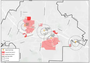
On Tuesday, the San Marcos City Council approved an ordinance exempting some areas of TOD zones that are in high fire zones and those that lack a direct pedestrian walking path to a transit stop. The ordinance was recommended for approval by the Planning Commission last month.
The city now has until the start of the 7th Housing Element Cycle in 2031 to phase in development on these fire-hazard sites or to develop alternative plans to redistribute housing capacity to other sites.
Principal Planner Sean Del Solar noted that SANDAG’s map was released after the city’s Planning Commission meeting, but that city staff did communicate with SANDAG for guidance while the map was in the works.
“There was a lot of coordination which took place regionally and with SANDAG and other jurisdictions to ensure basically that our ordinance was consistent with the latest guidance and also those implementation practices throughout the region,” Del Solar said. “Despite these timing considerations, San Marcos is still an early adopter of the comprehensive SB 79 implementing ordinance.”
The ordinance takes effect immediately and will also be reviewed by HCD. Planning Division Director Joseph Farace said the city has not received any SB 79 applications since the law took effect on July 1.
About half of the TOD zones around the Cal State San Marcos and Palomar College stations fall into the very high fire hazard severity zone, as do smaller areas within the Nordahl Road and Civic Center station zones, and these areas will be temporarily excluded from SB 79 projects.
Council members said they were not happy with SB 79’s implications for the community and its override of city control. Councilmember Ed Musgrove also shared concerns that SB 79 developers will not provide enough parking at their projects, with the justification that residents can just use public transit.
“It’s farcical what Sacramento is pushing down on us,” Musgrove said. “I will be supporting this for the sole purpose of maintaining what little control we have over our community and our development, but I’m not happy with it.”
SB 79 projects must have a minimum of five dwelling units and a density of at least 30 units per acre. Projects with 10 or more units must deed restrict either 7% of units for extremely low-income households, 10% for very low-income households, or 13% for low-income households.
The City Council unanimously approved the ordinance, except for Mayor Rebecca Jones, who said she would recuse herself out of an abundance of caution due to living within one of the TOD zones.