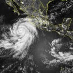
REGION — Hurricane Hilary has strengthened to a Category 4 status in the Pacific Ocean off the coast of Baja California today, with sustained winds up to 140 mph.
Hilary was gaining strength as it slowly moved northward off the coast of Baja California on a still-uncertain path that will bring heavy rain and potentially flooding to the San Diego County area, with precipitation possibly beginning as early as Saturday night but peaking Sunday into Monday.
According to the National Weather Service, patches of dense fog engulfed some coastal areas Thursday morning, and forecasters said temperatures dropped three to six degrees lower than they were Wednesday.
Valley areas will still reach into the triple digits, while the coasts will top out in the 70s, according to the NWS.
Hilary is expected to continue gaining strength, moving north over the next two days. However, by the time it reaches Southern California, it is expected to weaken to a Category 1 or even below hurricane or tropical storm levels, but the Southland will still have to cope with the remnants of the storm.
San Diego County was bracing for what is expected to be a significant surge of monsoonal and tropical moisture with widespread heavy rainfall thanks to Hurricane Hilary, which was gaining strength as it moved north off the coast of Baja California and could still pack a wallop when it reaches Southern California.
The brunt of the storm is anticipated in the county Sunday into Monday, with a high potential for flash flooding in the mountains and deserts.
The exact path of the storm remained in flux Friday, with forecasters noting that even slight shifts in its track could dramatically impact rainfall totals.
“Regardless of the exact track and intensity of Hilary, which could continue to change in the coming days, it will bring a substantial surge in moisture into Southern California, with heavy rainfall and a high potential for flash flooding, especially for the mountains and deserts,” according to the National Weather Service.
Forecasters said mountains in Riverside and San Diego counties could see 4 to 8 inches of rain, possibly up to 10 inches on some eastern slopes, between Saturday and Monday. Lower desert areas could receive 5 to 7 inches. Coastal areas are currently anticipated to get between and inch and an inch-and-a-half of rain, with valleys getting 1.5 to 2 inches.
The NWS issued a flood watch that will be in effect from Saturday morning through Monday in the San Diego County mountains, deserts, valleys and coastal areas, along with the Riverside County mountains and valleys, the Coachella Valley and San Gorgonio Pass near Banning.
Forecasters said the heavy rains could result in excessive runoff that might flood rivers, creeks and streams and cause debris flows in recent burn areas.
“In addition to the rainfall and flooding threat, another concern is the potential for strong east winds Sunday and Monday,” according to the NWS. “The wind threat will be more dependent on the track of Hilary. Should Hilary have a more westerly track, the wind threat would likely be greater, and if the track is more easterly, the threat would be less.
“The combination of heavy rainfall, the potential for flash flooding, and strong winds could very well make this a high-impact event for Southern California.”
Hilary is unlikely to still be packing hurricane strength by the time it reaches Southern California, but it could still be classified as a tropical storm. The NWS noted that the only time a tropical storm made landfall in California in the 20th Century was in September of 1939.
There is about a 15% to 20% chance of tropical storm force winds over the coastal waters Sunday night through Monday, not counting possible strong winds from thunderstorms, forecasters said.
A south-southeast swell produced by Hilary has some potential to bring high surf to south-facing beaches Sunday and Monday. There will also be a chance of lightning late Saturday through Monday