
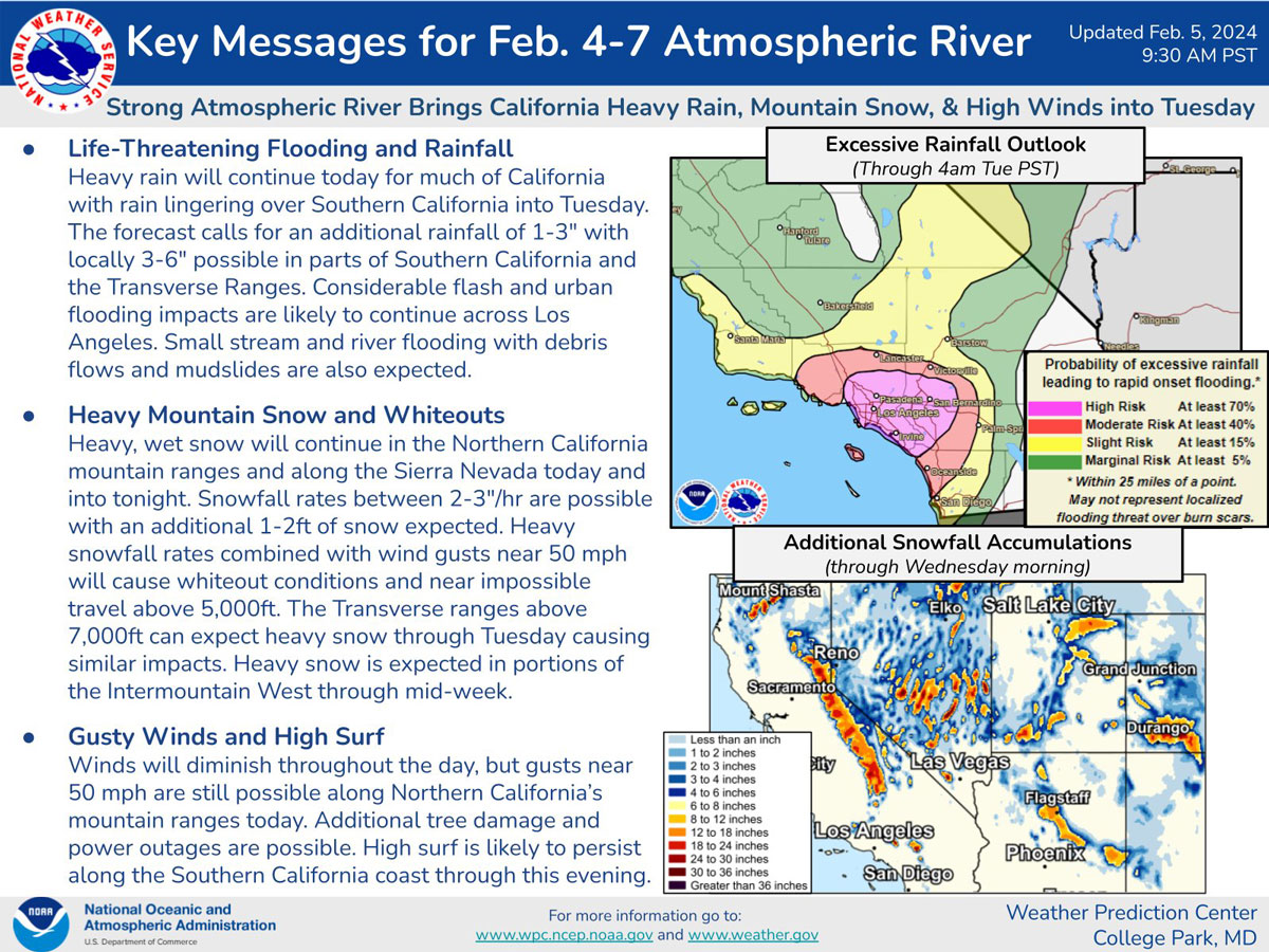
REGION — Another powerful storm is bearing down on Southern California, with at least three straight days of rain in the forecast for San Diego County and authorities warning of potentially dangerous flooding.
The first rain should arrive Sunday evening, with widespread heavy rain and mountain snow occurring Monday and Tuesday, according to the National Weather Service.
A flood watch will be in effect from 4 p.m. Sunday until 10 a.m. Wednesday, which includes San Diego and the county coastal cities of Carlsbad, Vista, San Diego, Escondido, Chula Vista, El Cajon, Poway, Encinitas, Borrego Springs, Santee, Julian, Oceanside, Pine Valley, San Marcos, National City and La Mesa.
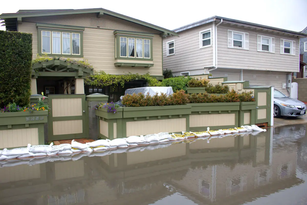
In Encinitas, city officials encourage residents to proactively safeguard their homes by utilizing the self-fillable sandbag stations at the Public Works parking lot, 160 Calle Magdalena, and Leucadia Roadside Park, 860 N Coast Hwy 101. Each resident is eligible for up to 10 free sandbags.
Excessive run-off could result in flooding of rivers, creeks, streams and other low-lying and flood-prone locations. Creeks and streams may rise out of their banks and flooding may occur in poor drainage and urban areas, the NWS reported.
A wind advisory will go into effect from 8 p.m. Sunday until 10 a.m. Monday and will include the cities of Oceanside, Vista, Carlsbad, Encinitas, Chula Vista, National City and San Diego.
Gusty winds could blow around unsecured objects. Tree limbs and palm fronds could be blown down, and a few power outages may result, with southeast winds from 15 to 25 mph and gusts up to 35 mph in some parts of the county, weather officials said.
A high-surf advisory will also go into effect from 10 p.m. Sunday until 10 p.m. Monday, with large, breaking waves from 6 to 8 feet and sets up to 10 feet. Surf will be highest on west-facing beaches in San Diego County, according to the NWS.
In addition, a small craft advisory was in effect from 10 a.m. Sunday until 10 p.m. Monday for coastal waters from San Mateo Point to the Mexican Border and out to 30 nautical miles, extending 30 to 60 nautical miles out, including San Clemente Island.
Forecasters said south-to-southeast winds will increase Sunday and Monday, with gusts from 25 to 30 knots, along with seas building from 10 to 12 feet and possibly locally up to 15 feet. Strong winds and choppy/steep seas will create hazardous boating conditions for Sunday morning through much of Monday.
Officials said dangerous swimming and surfing conditions and localized beach erosion could occur. Forecasters predict that high surf will likely decrease late Monday night and Tuesday, with periods of moderate to heavy rain expected Sunday night through Tuesday. A chance of thunderstorms Sunday night into Tuesday is likely.
County emergency services and public works road crews advised the public to stay alert and take precautions on the roads and offered the following tips:
— Avoid driving through deep water;
— Avoid oversteering or stomping on the brakes if you start to hydroplane or skid;
— Avoid texting or using a hand-held cell phone when driving;
— Slow down to avoid getting into an accident;
— Turn on your headlights to see better;
— Try to drive toward the middle lanes as water tends to gather in outside lanes;
— Defog your windows for better visibility;
— Never drive through a flooded roadway;
— Give the cars in front of you extra distance;
— Watch out for public works crews and equipment.
Sunday’s San Diego surf forecast includes a high-risk rip current, with a surf height of 4 to 7 feet and a water temperature of 57 to 60 degrees, with a mixed south swell of 200 degrees and a west swell of 270 degrees.
Forecasters expect a chance of rain in downtown San Diego Sunday after 4 p.m., with partly sunny conditions and a high near 62. The chance of precipitation is 30%, with new precipitation amounts of less than a tenth of an inch possible.
Partly cloudy and rainy conditions are expected in the mountains until mid-week, with highs in the low 50s. Cloudy and wet conditions are expected in the deserts all week, with highs reaching the upper 50s and low 60s, according to the National Weather Service.
Along the coast, partly cloudy and heavy wet conditions are expected this week, with daytime temperatures hitting the low 60s. Inland valley areas are expected to be hit with showers through Friday, with highs reaching the mid-50s to low 60s.
Alert San Diego has provided residents with all other information regarding flooding and can be found at the following links:
— Flood preparation information, www.alertsandiego.org/en-us/preparedness.html;
— Emergency information, www.alertsandiego.org/en-us.html;
— Recovery information including cleanup, medicine and additional helpful resources, www.alertsandiego.org/en-us.html.
The Department of Public Works is picking up flood-damaged debris and items from homes in the unincorporated communities. Pick-up in unincorporated areas can be reached at 858-495-5700. Additional storm recovery resources can be reached by dialing 211.
The county advised against putting debris near curbs during rainy weather, where it can wash away and cause a hazard.
This week’s storm comes after a spate of historically heavy downpours that left roadways, commercial districts and residential neighborhoods underwater across the region. The wettest day, Jan. 22, delivered the highest 24-hour rainfall amounts in San Diego since 1850, according to the NWS.
The inundation, which washed away many parked cars and heavily damaged or destroyed hundreds of homes, prompted the city and county of San Diego, along with Gov. Gavin Newsom, to declare a state of emergency.


1 comment
Meanwhile, the City of Encinitas has had 37 years to fix the flooding and drainage issues along the Vulcan-101 corridor, but would rather spend money on less-critical infrastructure improvements that can wait. Meanwhile as well, the state keeps cramming unrealistic, inflated densification down our collective throats, leading to even more runoff and flooding. Elections have consequences. Particularly at the state level, but also locally, vote the WIYBYs (Wall $treet In Your Back Yard) out, and vote in some pro-neighborhood people who actually care about quality of life in our established residential neighborhoods.
Comments are closed.