CARLSBAD — The final map is in and not much has changed.
In its final meeting, the Carlsbad Independent Redistricting Commission voted 4-3 to approve the city’s new electoral map during its Feb. 17 meeting.
The public submitted 76 maps, but in the end, the commission opted for a map created by the National Demographics Corporation, which was contracted by the city to facilitate and advise the commission.
The map goes into effect for the 2022 election and will be the map until 2031, according to Shannon Kelly of NDC. District 1 and District 3 seats are up for election this year. The mayor’s seat, a citywide election, is also up this year as Mayor Matt Hall is scheduled to retire.
According to city staff, 13,500 residents will move into a new district resulting in approximately 3,800 registered voters who will now vote in the 2024 election instead of 2022. The city’s population, adjusted by the state, according to the census is 114,593 with 81,457 total registered voters, Kelly said.
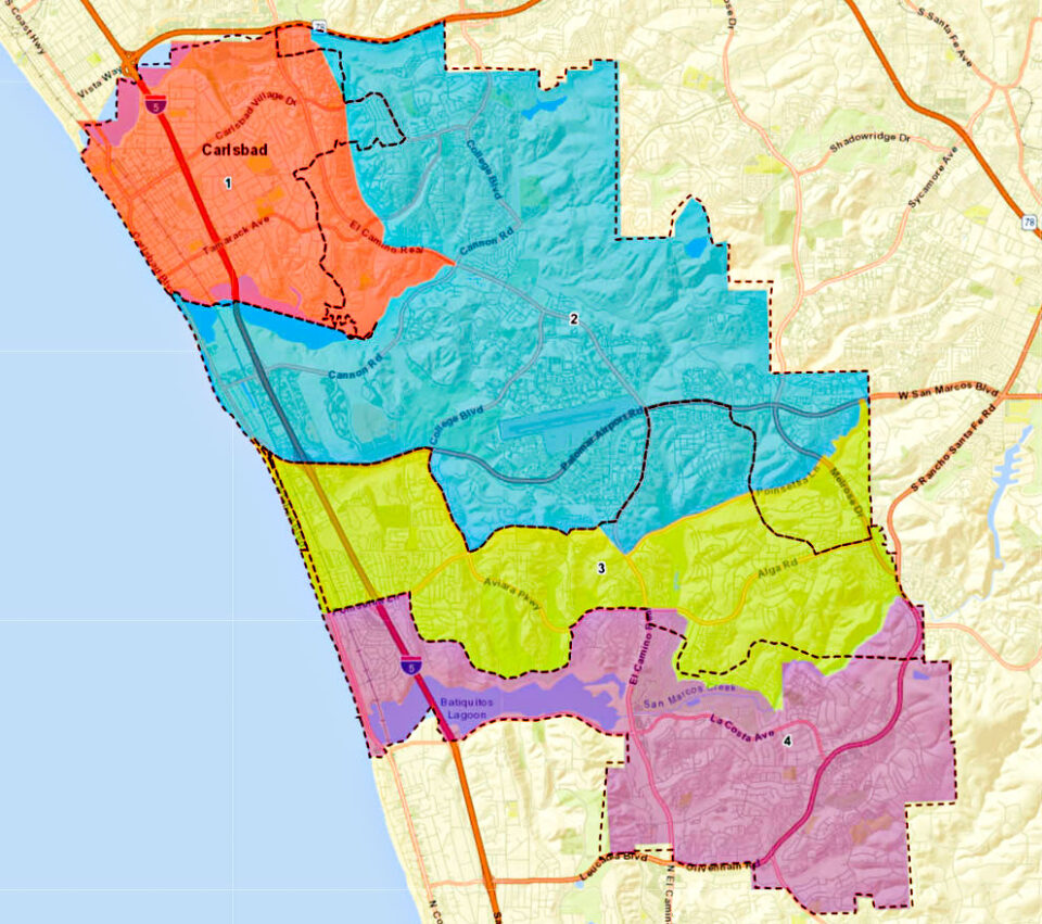
All the districts mimic the previous map, which was a priority for many on the commission, along with most residents who submitted comments or spoke during public comment. The city’s first-ever map had four coastal districts along with each having segments of Coast Highway, the railroad tracks, Interstate 5, El Camino Real, business parks and bordering a neighboring city.
“Nothing is going to be perfect,” Mary Stanley, vice chair of the commission, said of adopting the new map. “We’re always going to want to tweak something. We’re here to make a decision and it has the least amount of disruption.”
The new map has several differences from its predecessor, which was adopted by the City Council in 2017. Notably in District 1, the boundaries extend east of El Camino Real and north of Tamarack Avenue and consist of about half of the Tamarack Point neighborhood.
Additionally, the district continues south and west of El Camino Real to Cannon Road to include the neighborhood encompassing Kelly Elementary School, which was previously in District 2.
In District 3, the most notable change is Bressi Ranch, which moves into D2 and out of D3, while Rancho Carrillo is split between D2 and D3.
The new D3 portion of Rancho Carrillo is south of Poinsettia Lane and swings northeast to Business Park Lane and Palomar Airport Road. The border between D3 and 4 mostly follows San Marcos Creek.
In D4, much of the district remains as is as it borders Encinitas to the south and San Marcos to the east. However, the notable changes are the district extends north between Alga Road and Alicante Road, east of El Camino Real.
Residents east and north of the La Costa Omni Resort golf course, though, will shift into D3.
“It was a really robust process,” Kelly said. “There was almost a split between the four coast districts and two coast districts. It came down to did they want to stick to the four coastal districts. There was definitely a loud voice to keep that. I think it was interesting the four maps in the end … two coast districts and two quadrants. I think the commissioners were thoughtful and, in the end, … they wanted to minimize change.”
As for the city’s population, Kelly said the Census Bureau calculated Carlsbad’s population at 114,746, but the adjusted population takes into account incarcerated individuals from their last known address.
Per California law, the address for an individual serving a jail or prison sentence is not where they are incarcerated, but from their last known address, Kelly said.