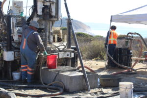
DEL MAR — It’s a sunny day near Torrey Pines State Beach on Oct. 23, and engineering geologist Nathan Burt is examining cylindrical samples of blueish-green earth brought up moments ago by a humming boring machine.
The drill rig collects vertical samples every five feet, reaching a depth of 220 feet over several days. Once each sample is collected, the drill is brought back up, and a removable stainless steel sleeve comes apart to reveal a foot-long core of solid earth.
“They’re going to come apart like this, and they’re going reveal a beautiful core,” Burt says, explaining as a sample is placed into a box labeled with the associated depth. “In terms of Delmar, what we’ve been seeing, this is a really good example of this grading from a coarser-grain fine sandstone into a siltstone, mudstone, and then you can see it alternates back.”
These samples of Delmar Formation, estimated to have formed approximately 48 million years ago, were collected from a worksite near the intersection of Carmel Valley Road and North Torrey Pines Road. The site is one of 28 boring locations where crews are collecting soil samples as part of geotechnical work for SANDAG’s Del Mar rail realignment project.
The project aims to reroute a 1.7-mile section of the LOSSAN (Los Angeles-San Luis Obispo-San Diego) Corridor away from the fragile Del Mar bluffs and further inland. In March, the SANDAG Board of Directors approved four alignments for further environmental study, three of which propose tunneling underground.
HDR Engineering, which is leading geotechnical work for the project, is boring down to collect samples at various locations along these proposed tunnel routes to assess the soil and groundwater conditions.


By examining the soil density and other conditions, crews can ascertain the potential impacts on vibration, noise, and groundwater if a train tunnel were to be constructed.
“It’s one of the questions we keep getting asked by the public,” SANDAG Environmental Compliance Manager Keith Greer said. “That’s the kind of stuff you need these tech reports to be able to answer. I keep saying to the public, ‘This information is going to come.’”
This geotechnical information, along with studies related to air quality, noise, traffic, water, biological resources, visual character, and property, will eventually be incorporated into a draft environmental impact report (EIR), which will then be circulated to the public.
All of the proposed tunnel routes originate near the San Dieguito Rail Bridge, with one running under Crest Canyon in Del Mar, another under Camino Del Mar, and a third running east to Interstate 5 and then following it south.
The fourth option is to keep the tracks at their current location on the Del Mar bluffs and add double-tracking.
The boring site, where crews are set up on Oct. 23, is located at the intersection of Carmel Valley Road and North Torrey Pines Road. This is the proposed location of the southern tunnel portal in the alignment running under Camino Del Mar.
In this alignment, the train would exit a tunnel via a portal in an open space area east of Torrey Pines Road, connecting to the existing rail tracks before continuing south over the Los Penasquitos Lagoon.
As of late October, SANDAG and HRD had completed sample collection at most of the planned boring sites in Del Mar. This includes several near the San Dieguito Lagoon and the Del Mar Fairgrounds, along Camino del Mar, and in the Crest Canyon area.


Additional boring needs to be done along portions of proposed alignments south and east of Del Mar and into San Diego, including along I-5, further southeast in Crest Canyon, and south of Carmel Valley Road.
Officials said the depth of the samples they pull ranges from 100 feet in some locations to over 300 feet.
“The depth we go to is dictated by the alternative alignment, and how deep that alternative alignment is potentially going to be. We make sure we cover to a depth below that, so we have enough data to analyze to do testing and assess the soil properties, so we can use that to inform our engineering,” said Lorenzo Garrido, HDR Principal Project Manager.
The agency is currently utilizing $300 million in state funds, obtained by former state Sen. Toni Atkins in 2022, to complete the environmental process and advance engineering work. These funds will expire in 2027.
Funding for construction remains to be identified. The project is estimated to cost between $2 billion and $5 billion, depending on the alignment of the project.
According to SANDAG staff, the final EIR for the project will take around three years to complete. The goal is to have the tracks off the bluffs by 2035.
SANDAG has stated that alignments may be refined and changed further during the environmental review process. Alignments proposed over the past couple of years have been revised multiple times during various reviews and based on community feedback.
Major concerns related to the project include impacts on private property and existing infrastructure, as well as long-term environmental impacts. With a project of this size, Greer said all of the alignments will have effects that need to be taken into account.


“They represent a range of options out here. Each one has their own different tradeoffs, they have challenges, and ultimately we’ll be feeling the environmental consequences of all those alternatives,” Greer said. “It’s a big project, it’s a complicated project. But, the environmental methodologies are very straightforward. Nothing we are doing is unique or new.”
More information about each route and the location of proposed tunnel portals is included below:
San Dieguito Bridge to I-5 — 5.3 miles long, $3.7B-$5B cost
This alignment would begin at the south end of the San Dieguito Rail Bridge, which is scheduled for reconstruction as part of the San Dieguito Double Track Project. The route would continue south, passing over Jimmy Durante Boulevard and then crossing Racetrack View Drive on a bridge.
It would enter a north tunnel portal in Crest Canyon Open Space Park south of Racetrack View Drive, and head southeast in a tunnel along I-5 before exiting a south portal at a knoll along the highway, and rise above ground to connect to the existing tracks north of the Sorrento Valley Station.
The notice of preparation for the draft EIR also describes another design variation for this route, beginning north of the San Dieguito Lagoon Bridge at the planned special events rail platform and heading east along the edge of the Del Mar Fairgrounds before entering a tunnel along the interstate.
Under Crest Canyon — 5.1 miles, $3.7B-$5B cost
This route would begin south of the new San Dieguito Rail Bridge and enter a north tunnel portal under Jimmy Durante Boulevard near Camino del Mar.
The tunnel would travel beneath Crest Canyon and then exit above ground via a south portal at a knoll near I-5 south, rising above ground to connect to the existing tracks north of the Sorrento Valley Station.
Under Camino del Mar — 4.9 miles, $3.3B-$4.4B cost
Like the Crest Canyon alternative, the Camino del Mar alternative would descend immediately south of the new San Dieguito Rail Bridge and enter the north tunnel portal under Jimmy Durante Boulevard.
It would then continue south, mainly following under Camino Del Mar, and exit a south portal near the intersection of North Torrey Pines Road and Carmel Valley Road. The tracks would continue on the bridge over Los Peñasquitos Lagoon and rejoin the existing railway.
This alignment would also double-track the existing rail bridge across Los Peñasquitos Lagoon, necessitating the widening and raising of the berm.
Bluffs Double Track reinforced – $1.9B cost
This option would keep the tracks at their current location along the bluff, add a second track to achieve double tracking, and enhance bluff stabilization infrastructure.
This alignment would also involve lowering the tracks into a trench south of the Camino Del Mar roadway bridge so that they pass under Coast Boulevard, removing the current at-grade roadway crossing.